Cark to Grange . . .

. . . the long way! It was such a beautiful day that I just had to play truant. At first I intended going for a long walk from Grange now that the railway line has finally re-opened, but I remembered that I need to improve my cycling fitness so I switched to the bike.

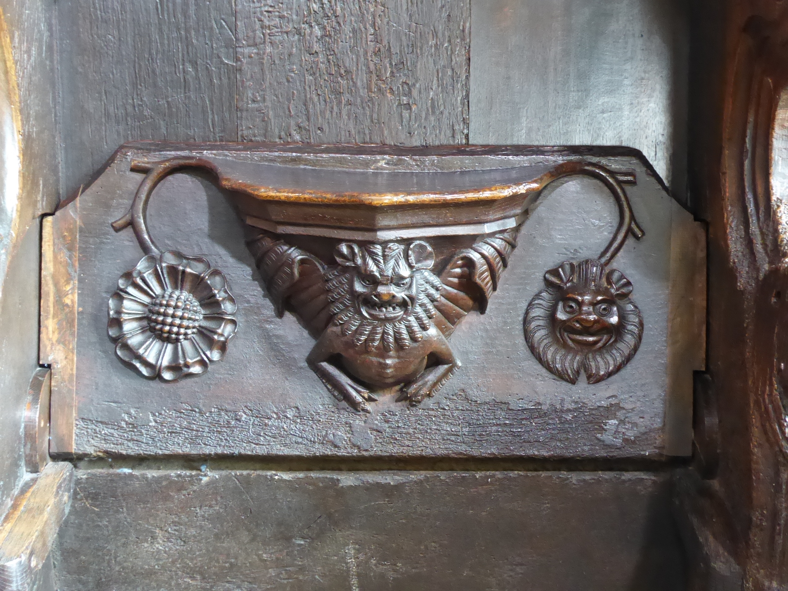
Train to Cark, then Cartmel, where I found the priory church open and finally visited the interior after seeing the massive building so often from a distance. The 15th-century misericords are wonderful, and it’s interesting to see the style shift from Romanesque to Gothic as the chancel and transepts give way to the nave.

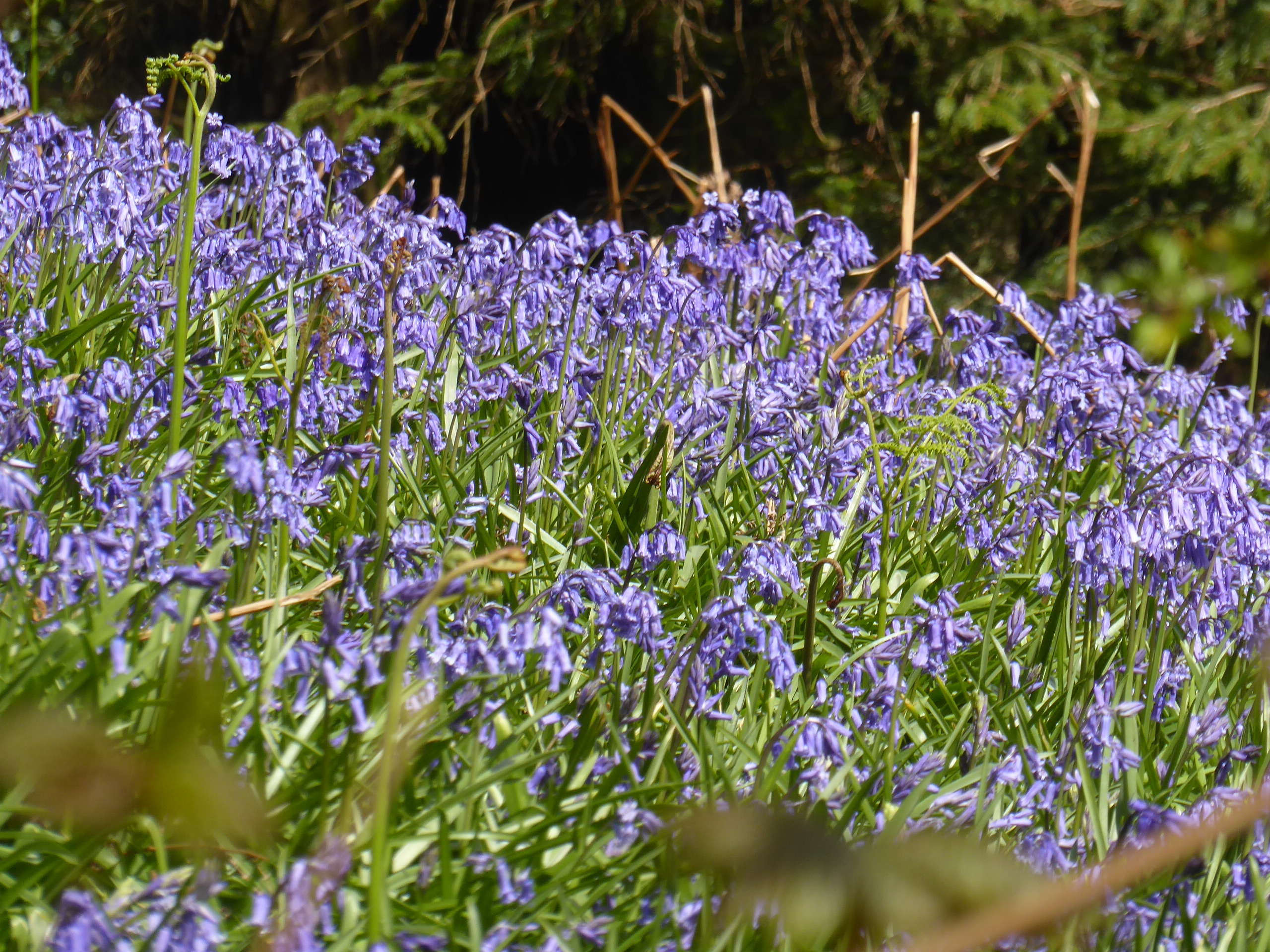
Then to High Newton and over Newton Fell, where I ate my sandwiches with a big view over the Winster valley. There were bluebells and wild garlic everywhere, and I realised how starved I have felt of the “incidentals” of sunshine, like shadows and slanting light. Then Witherslack and a coffee at the Derby Arms – where I realised that if I could cover four miles in 25 minutes (no guarantee: I’d been making heavy weather of cycling up to that point) I would catch the next train from Grange.

In the end I pulled into the station just as the train drew to a halt. I ran up the ramp and found myself right in front of the carriage door with the cycle logo. A satisfying end to a lovely day.

Yanwath

An ad hoc walk to Yanwath to see the hall that the railway line flies past. The idea was to go further but mud and the difficulty of finding the right way made it an unattractive prospect. Instead I chose a route that looked as if it went back to Penrith . . . but it was in fact blocked by a council depot. A word and a smile provided the Open Sesame (oh, the advantages of looking harmless!) and there was no need to trudge all the way back to the main road.

A reminder though that I need to improve my map-reading skills.

Eamont Way

I am Penrith again. Not the weather for it – storms and yet more rain – but I should know by now how to make the best of things.

I walked to Pooley Bridge mostly along the Eamont Way. Into a headwind. It was – as I’d expected – very slippery and muddy. Fortunately little rills (previously known as “footpaths”) washed my boots clean as I walked. Over the motorway, under the railway (built in brick stripes – that I loved) and across the fields. I stopped to look at St Michael’s Church in Barton – dating from the 12th century and reshaped over the centuries. It was in Barton that I walked across a farmyard: a couple of new lambs with their mothers in a pen, a collection of old farm machinery, a large Tudor-looking farmhouse that must be a devil to maintain – and an elderly farmer carrying a pail and walking with a limp along a muddy path. Now that looked like a hard life.

At Pooley Bridge I considered walking back on the opposite side of the river . . . but there was a bus to Penrith due in 10 minutes, the prospect of cheese on toast at Cranston’s and the chance of going to the cinema at teatime. No contest.

Long Meg and Her Daughters

At present any day without rain, no matter how grey, counts as “fine” – so it was “carpe diem” today.

The Brompton came out for the first time in (gasp) two years. Trains to Carlisle and Langwathby, and from there I pedalled (and walked) the couple of miles to the stone circle. It straddles a farm road – which at first sight seems intrusive, but presumably it’s a millennia-old path that now happens to be tarmacked. Long Meg stands apart from the circle: it’s a red sandstone monolith and on the winter solstice the setting sun casts a shadow across the centre of the circle. Her “daughters” are glacial erratics – 68 of them.

I decided to cycle further to the site of an old cross marked on the map: it turned out to be an old hammerhead cross in the churchyard of St Michael and All Angels, Addingham. This was a tiny church – much restored over the centuries, but indefinably “ancient”, with a Viking hogback grave marker in the porch.

Exploring over and my curiosity satisfied, I headed to Penrith and the station, walking up the long drag from the River Eden. I hope it won’t be another two years before I get the Brompton out again. No one to hold responsible but myself for that.

Brough Castle

The bus was an old-fashioned double-decker where passengers were given the option of taking the scenic route to Barnard Castle – mercifully after I had got off. My second visit to Brough Castle, and this time I had the chance to look round it. It once belonged to – of course! – Lady Anne Clifford, who restored it after the Civil War.

Then a gentle walk back to Kirkby Stephen, taking in more of the River Belah. As I stopped for lunch I noticed a dipper on the opposite bank.

Belah Viaduct

My curiosity about the old Stainmore line, between Barnard Castle and Tebay, continues. I developed an unlikely urge to see the site of (rather than the sight of) the Belah railway viaduct. Designed by Thomas Bouch (he of the Tay Bridge disaster), it opened in 1861 and was closed 101 years later. Photographs of the bridge bring to mind a giant meccano construction. Today there are only the stone abutments, facing each other across the Belah valley, and a crumbling signal box.

It is a longish walk from Kirkby Stephen to the western pier, so I adopted a utilitarian approach and walked on minor roads with hardly any traffic. I had my sandwiches at the foot of the abutment, looking across the valley to its eastern twin, and listened to a buzzard mewing above me. I walked up to the old track bed: I swear I could see the incline needed to carry the line over the Stainmore Summit: it was steep enough for trains to require an extra locomotive. On my return I caught a glimpse of nearby Redgategill Viaduct and Brough Castle. All in all, a lovely day.

Matterdale Common

The thing about not walking solo is that I don’t look round much and I don’t take photos. The latter irks me slightly, and as today’s walk was almost completely new to me I made an effort to stop and get out my camera.

The bus to Aira Force again and then the chance to satisfy my curiosity about the long track over Matterdale Common marked “old coach road” on the OS map. You can use it to get to Castlerigg stone circle and down to the Keswick road for the (hourly, thankfully) bus back to Penrith. An old coach road, I reasoned, isn’t going to involve scrambling or steep descents, both of which I avoid. What should have occurred to me – and it’s fairly obvious from the map – is that it would be long and bare. Fortunately it was neither wet, windy nor baking hot. The descent to Wanthwaite was quite steep and very stony (the problems of maintaining heavily ab/used paths) . . . but is signposted as the C2C cycle route at the bottom. Definitely not one I shall be trying.

Our second lunch stop was in a damp field full of thistles. No Eyeore but lots of butterflies and beetles, which was a lovely change from stones and bare fell. At Castlerigg I looked back at our track with a degree of satisfaction and the thought that I need never do it again.

Aira Force

The bus to Aira Force, then a walk contre la montre to Pooley Bridge for the return journey. Gowbarrow Fell, Bennethead (where we directed some rather fed-up-looking Duke of Edinburgh teenagers with enormous packs) and Waterfoot. We rejected the thought of going on a gin cruise advertised at the jetty and headed to the bookshop for a coffee instead.